Note: The Deckman download will run in demonstration mode if you have not purchased a valid Deckman licence.
B&G Deckman software is ever evolving, in order to introduce new features for the user at regular intervals. With version 9 released in March 2008, v9.1 now adds even more functionality to further enhance usability.
Integrated weather and routing features introduced in Deckman v9.1
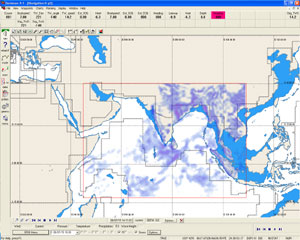
The main enhancement in version 9.1 is with the GRIB weather and routing. Previously Deckman displayed wind (speed and direction), barometric pressure and sea temperature. In v9.1 we have added the option to display precipitation (rainfall) and wave height.
New in v9 AIS overlay
View all boats equipped with commercial or leisure AIS NMEA 0183 transceivers. Targets are provided as a chart overlay, with options to add vectors in front of moving targets. Used for collision avoidance and competitor positioning.
Further vessel detail, including name, call-sign, course and speed, is available by clicking on the target displayed.
Weather enhancements
Deckman’s weather services have been enhanced by several additions:
Weather Animation gives a clear visualisation ofhow the weather is likely to develop
Precipitation display provides clearer identifi cation of weather front positions
Wave Height display gives the navigator information on the likely sea-state ahead
GRIB file manager allows loading and prioritisation of multiple GRIB files, allowing local high-resolution data to be used alongside wider area.
Advanced GRIB options allow the advanced user to modify GRIB files based on observations.
UGRIB service now provides wave height alongside wind, pressure and precipitation

The Optimum Routing module now includes the option to avoid areas with waves larger than a user set height – increasing speed and reducing the risk of damage to the boat offshore.

Key Features and Benefits
- Display of Precipitation from GRIB files that allows clearer identification of weather fronts
- Display of Wave Height from GRIB files that allows the navigator to see the likely sea-state on the route
- Animation of GRIB files enables a clear visualisation of how the weather is likely to develop
- Use of Wave Height in Optimum Routing allows the navigator to route around waves over a certain size, increasing speed and reducing risk of damage
- UGRIB service has been updated to allow downloading of rainfall information. Fully integrated weather downloads from UGRIB, along with the existing Saildocs and OCENS Weathernet* services allow the user a choice of the leading weather services
- Multiple GRIB files may be loaded at the same time allowing a local hi-resolution file to be used alongside a wider area, lower resolution file, for example
- GRIB Manager allows the user to control and prioritise which GRIB files are in use
- Advanced GRIB options allows the advanced user to modify GRIB files
*Note: OCENS Weathernet is a subscription service
Deckman V9 is compatible with many instrument systems including the B&G H2000, H3000 and WTP systems.